This is the year America is 250 years old. Fifty-years ago, America turned 200. It was a big deal back then. Everywhere, people were linking the past to the present and celebrating the history of the places they lived and worked.
This year, it seems the celebrations are few and far between. It’s like collectively, people forgot history. Or maybe that the world is too with us, as Wordsworth wrote many years ago.
In the spirit of ’76, let’s celebrate the bicentennial edition of Norwalk’s bike routes.

The guide was produced by the Norwalk Board of Education and reprinted several times. The text and the tours were prepared by the planning and zoning staff. So let’s give a shout out to Ed Leary, and of course Mike Green and Mike Wrinn who always made sure that Norwalk’s history was part of how we viewed zoning. During my time on zoning, they made sure to tell commissioners the hitsotry of Norwalk as part of our review of zoning code, and proposed developments. Celebrating a bit of Norwalk history in government is a great thing.
For the curious, in 1976, printing was more involved than it is today. Artwork needed to be scanned and then plates created in metal for printing presses. The brochure front above shows hand-drawn elements and linotype lettering. Linotype was a foundry that made acrylic letter forms of different sizes so that layout designers could create copy (words, sentences, and paragraphs.)
It wasn’t until the mid 1980s that the idea of personal laser printers would enable anyone to print copies from a personal computer.
The production process, then, took many people and many specialized steps to produce anything. That is why the proofing process was critical; it was expensive to correct metal printing plates. It also explains why errors were important to catch before the final print run.
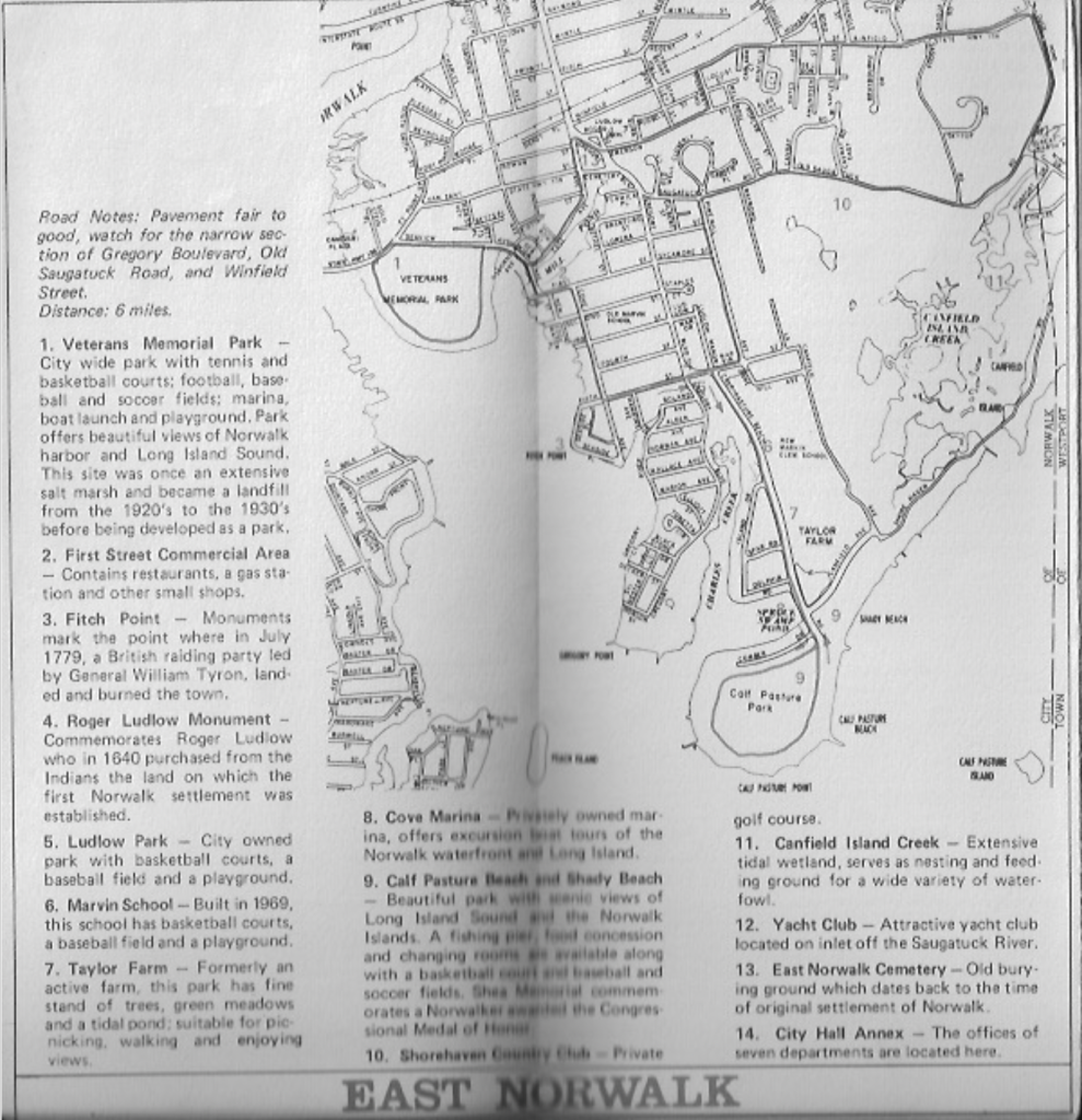
Bike Routes in 1976 were identified in Rowayton, East Norwalk, West Norwalk, Silvermine and Cranbury. And of special note, they included general information about the road conditions.
For example, for Rowayton it said, “Pavement fair to good, most of the roads are narrow. Watch for traffic on Rowayton Avenue and Flax Hill Road. Distance 6 miles.”
I did not do the original scanning. So apologies for the blurry images. Part of the reason I write here, and post these things is to continue preserving these connections to how Norwalk once was.
- Brien McMahon High School. Public parking is available here at the High School is named after a U.S. Senator from Norwalk.
- Flax Hill Road – A winding Road with interesting old houses on it.
- Old Schoolhouse, Brookside Cemetery, and Darien Town Line – Flax Hill continues past a privately owned one-room schoolhouse, the cemetery, and the Five Mile River markting the boundary between Darien and Norwalk.
- White Bridge and Five Mile River – Crossing back to Norwalk is a general store and service station, and the White Bridge Crossing of the Five Mile River.
- United Church of Rowayaton and Cemetery – A distinctive modern church.
- Pinkey Property – Harborfront park area owned by the sixth taxing district.
- USS Tallapoosa Cannon – Cannon from an old Civil War Vessel
- Rowayton Commercial Center – Interesting blend of yachts, shops, restaurants, an art gallery, an old fire station, and Victorian houses.
- Ship Captains and Sea Merchants Houses – An old mansion and a group of smaller frame-houses mark the spot where seafarers staked their hoesites.
- Roton Point and Farm Creek – To the north is a large tidal marsh – look for ibis, egret, and heron; to the south Long Island Sound and Roton Point, the site of a former amusement park.
- Bell Island Beach – An excellent view of Long Island Sound, and on a clear day Long Island.
- Bell Island – A former summer colony, evidenced by a cluster of cottages, most of which are year-round houses.
- Hickory Bluff Store – A general store on the waterfront which rents sailboats and sells fishing gear and other marine articles. Look eastward for the Norwalk Islands.
- Thomas School – Formerly a private girls school; stable buildings and grounds.
- Roton Middle School – Tennis, basketball, and softball at the point where Highland crosses the ConnRail main line.
- Rowayton Railroad Station – Suburban station on the main line of the New Haven Division of ConnRail main line.

For the most part Rowayton’s historic places are still intact.
East Norwalk has seen many changes, but it too has most places still intact, wlthough sometimes repurposed.
West Norwalk, Silvermine and Cranbury have less places of interest, but these are the neighborhoods that completed this 1976 Bicentenial celebration of Norwalk’s history.